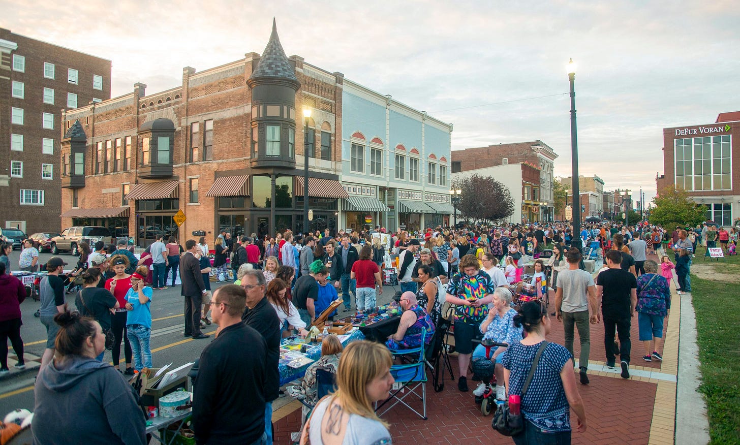
A view of downtown Muncie, IN, a city 60 miles northeast of Indianapolis. Source: downtownmuncie.org
Have you ever given much thought to satellite cities? Cities located close to major metropolitan areas that aren’t the primary city, yet have a strong identity and history of their own? Cities miles away from the central city core but with many strong urbanism elements and with outstanding cost of living affordability? Satellite cities are located near many large metros, but they’re rarely considered as places that people will consider as an affordable urbanism alternative.
I first noticed satellite cities when I moved to one, Muncie, IN, while in high school. Once we moved to Muncie, I saw that there were many other similarly sized communities in central Indiana, anywhere from 30 miles to 60 miles or so away from Indianapolis – Kokomo, Anderson, Muncie, Bloomington, Lafayette – that had long histories of their own, but had relationships with the Indiana’s capital and largest city. Each of these cities started out as agricultural trading centers for surrounding farmers and then became mid-tier industrial hubs in the 20th century. Each also suffered from deep deindustrialization that set in during the 1980s. Recovery for them has been spotty; Bloomington (home of Indiana University) and Lafayette/West Lafayette (home of Purdue University) haven’t suffered the same decline as the others, thanks to the pull of flagship universities. Ball State has helped Muncie, but it hasn’t gotten the boost that Bloomington and Lafayette did.
Later, I started to notice similar relationships surrounding other large Midwestern metro areas. When our family moved to Chicago, I saw some similarly positioned cities surrounding Chicago – Waukegan, Elgin, Aurora and Joliet – in the same light. However, they were all doing somewhat better than their central Indiana cohorts. I saw the same surrounding other major Midwestern metros, all in various stages of decline or revitalization.
(Note: I find this to be almost exclusively a Midwestern phenomenon, with a few exceptions. Similar satellite cities exist in California, whose settlement owes a lot to the Midwest. California’s versions also seem to be further from the core cities. The East Coast may have once had satellite cities like the Midwest, but a case could be made that metro amalgamation began occurring there even before industrialization really took off, so the region’s cities began evolving into the more familiar Megalopolis. No similar cities appear to exist in the South.)
These are what I’ve called satellite cities. They are midsized cities that experienced a period of growth during an independent phase of development but soon found themselves being pulled toward the gravitational pull of the larger nearby metro area. Some have been fully captured by the larger metro’s pull, others haven’t fully made the transition.
I wanted to do some investigation into the histories of these cities in the Midwest. To do so, I identified five criteria to tease them out:
1. It is a city that is a county seat or largest city in a county.
2. However, it is a city that is NOT the primary city in a metro area with a population over one million.
3. But it is a city that reached at least 50,000 residents by 1960, granting it relative independence from the primary city.
4. It is a city that is part of or adjacent to a metro area with a population over one million.
5. It is a city that is located about 20-70 miles outside of the metro area’s primary city.
Here’s a table of the 28 cities that I found that fit the criteria:
A few things of note. First, the cities highlighted in red are ones I fudged. Elgin, was just 500 people short of 50,000 in 1960, while Muskegon was just 1,500 people shy of 50,000 when it hit its peak in 1950. Independence and Waukesha are within the 20-mile distance from the primary city.
Second, I ordered the 17 metros above by population size, and the astronomical theory that larger planets have more satellites holds true for cities as well. Chicago has the most with six. Indianapolis is second with five, but appears to be an outlier. Detroit and Cleveland are next with four each. Lastly, I couldn’t find any city that came close to the criteria in the Twin Cities, St. Louis and Louisville metro areas. The Minneapolis/St. Paul region has plenty of large suburbs surrounding it, but they seem to be more of the post-WWII suburban boom variety. St. Louis and Louisville are dotted with hundreds of small suburban hamlets. Not sure why no such cities developed around them, but the fact that these are all river cities might have some to do with it.
I know I’m hardly the first urbanist to notice parallels between astronomical satellite systems and the relationship between large cities and surrounding hubs. In astronomy, actual satellites are categorized by their distance and gravitational pull from its parent planet, and it’s recognized that in our solar system that the largest planets have the greatest and most diverse number of satellites. Satellite system framing has been part of urbanism discourse for some time, from early study of relationships between cities and surrounding rural areas, to Ebenezer Howard’s Garden City concept. More recently it’s seen in how urbanists think of metropolitan structure organized as multi-nodal places, urban villages, or 15-minute cities.
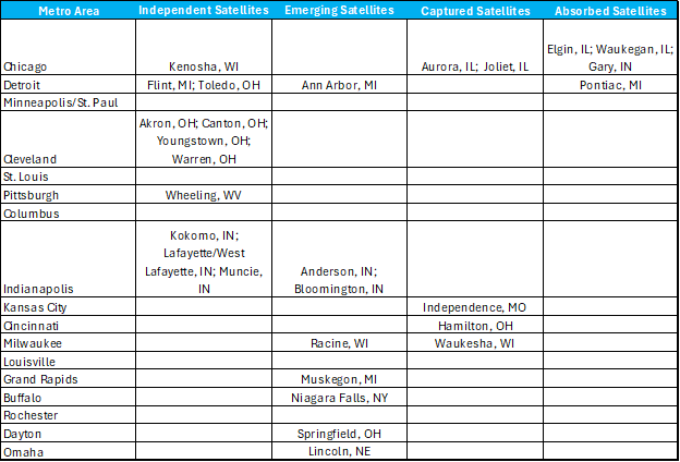
Independent: Self-sufficient midsized cities with long histories located within short distance of a large metro area. They could be considered an option for large metro residents seeking greater affordability and quality of life.
Emerging: Like the independent satellites, except the larger metro’s expansion is more quickly approaching the smaller city. The larger metro is coming toward the emerging satellite and exerting greater pressure on it.
Captured: The suburban expansion of the larger metro area now touches the satellite city on multiple sides. Captured satellites have a unique blend of old and new. In the Midwest that might mean pre-WWII neighborhoods that once housed the satellite’s manufacturing workforce sharing space with more recently constructed suburban development.
Absorbed: The satellite city has been surrounded by the metro area’s outward expanding development and continues moving beyond it. Absorption can take a couple of forms. On the one hand the satellite city can become a great example of urbanism integrated into the broader suburban framework. On the other, it could simply be bypassed and continue on whatever path the satellite city was forging when it was fully independent.
Here's my best guess at organizing the Midwest’s satellite cities by the four categories:
What is intriguing to me is how satellite cities can – or are willing to – adjust their perceptions about their cities and accept a new position in the hierarchy of cities in the Midwest. While many may not view it in this way, satellite cities are fortunate in that they have proximity to major metros, providing them with opportunities that other cities of similar size simply don’t enjoy. They have a chance to participate in and contribute to the global economy that the larger metros are already seeking to join.
I see four possible outcomes for satellite cities in their near and mid-term economic futures:
Link – They can develop stronger ties to larger metros that can lead to better economic opportunities for residents. This seems to be what’s happening with the satellites surrounding Chicago.
Cog – Their unique position between large metros means they can work in concert with them to create multiregional economies. Three satellites stand out in this regard, both in Ohio – Dayton, Springfield and Akron. Dayton is in a unique position to link, possibly through Springfield, the Cincinnati and Columbus metro areas. Akron could likely do the same, uniting Cleveland and Pittsburgh by way of Youngstown.
Catalyst – These satellites have another layer of economic production that could contribute to the growth of the adjacent larger metro. Ann Arbor, MI, Bloomington, IN and Lafayette/West Lafayette, IN, three college towns not far from large metros, may have a much stronger future role in the economies of Detroit and Indianapolis, respectively.
Stasis – These satellites appear to be in a holding pattern, waiting on economic circumstances to return to previous levels. While waiting, decline settles in. This may be the case for Pontiac, MI; Gary, IN and Waukegan, IL.
I’d love to hear readers’ thoughts on this. Part of me thinks satellite cities might hold the key to the transformation of other midsized Midwestern cities located even further from major metro areas. They can offer a proof of concept. Would you agree or disagree? I’m also wondering if readers can provide some input on similar dynamics in other metro areas. Are the Inland Empire cities of Riverside and San Bernardino the captured satellites of Los Angeles? Are Stockton and Modesto a couple of Central Valley cities feeling the pressure of the high-cost Bay Area nearby? Is Athens considered as a satellite city of the Atlanta metro?
Let me know.


I grew up in Springfield and went to college at OSU. I’ve been mystified for 35 years why Springfield doesn’t link Dayton/Cincinnati and Columbus. It’s obvious to anyone who knows how to read a map (which, alas, isn’t many people in Springfield). We got TV from both markets, and even when I was in elementary school, I realized Columbus was the future. But I’d bet the median Springfielder doesn’t visit Columbus even once in a year. To their credit, the civic leaders do seem to be pursuing this strategy; it’s just that nobody is playing along. I think a big part is that Columbus remains a fairly cheap city. Springfield’s property values are a lot lower (although that’s changing a bit because of the Haitians), but suburban/exurban Columbus is still affordable for a lot of people, so they’re not moving further west to save money yet. Meanwhile, the Air Force base is a big driver of Dayton’s economy, and thanks to its location, it’s closer to Springfield than it is to much of actual Dayton. Some parts of Springfield are only ten miles from the base. And there are two big malls near the base, where Springfielders shop now that our mall closed. (That’s probably why our mall closed, to be honest.) so we’re pretty tightly linked to Dayton, but still shockingly loosely to Columbus.
I would think the racial makeup of these places would be a salient point. Pontiac is 47% black, and 22% Latino. Anderson, Indiana is overwhelmingly white, by contrast (though has a decent sized black minority).
Pontiac is also located in one of America's premier wealthy counties. (Waukegan in Lake County, IL is similar). Whereas Anderson and Kokomo are the hubs of counties that were always middle class at best.
When you have heavily minority cities surrounded by affluent white/Asian areas, it's a recipe for your insulated/isolated dynamic. Connecticut cities are the perfect example of this. Bridgeport is only 16% white, for example, and is a stark contrast with the surrounding areas. Next door Fairfield is 91% white, for example.