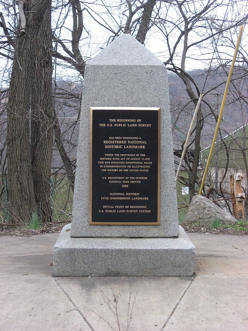
Source: wikipedia.org
Today’s piece will be a little nerdy, perhaps a little lecture-y. You’ve been forewarned.
I often think about why American cities seem almost incapable of capitalizing on their assets, of routinely and easily making the case for greater investment from the federal and state levels of government. We struggle to make public transit investments. We struggle with implementing good placemaking practices. We struggle with undoing bad urban policies, and instituting good ones.
In a nutshell, America struggles with doing things that work toward the common good, and has a firm belief that improving the lives of individuals is the best way to improve the common good.
Public health is another example of the same phenomenon. America is fine with having the best and most advanced health care system in the world – for some. But extending that common good to the masses so that many more can benefit from it is a bridge too far. We don’t like “freeriders”.
The emphasis on individualism in America can be traced to several cultural, political, and historical factors. This bias often manifests in political rhetoric, policy priorities, and societal attitudes that tend to favor individuals over groups, and private priorities over commonly shared goals. We can easily call to mind all the things that have historically made this happen in America; our historical roots in agrarianism and our preference for localized representation and government stand out. Put these things and others together, and it becomes clear why great American cities are the rare exceptions, and not the rule.
I’d argue that America’s individualistic culture is at the heart of making decent cities good, and good cities great. In fact, the nation has had an anti-city bias since its settlement and founding, and it’s baked into the nation’s fabric.
Two Early Acts
Let me introduce you to two early acts of the U.S. Congress of the Confederation, the Land Ordinance of 1785 and the Northwest Ordinance of 1787. They probably receive less attention than they should because they were acts passed under the Articles of Confederation, the organizing document that preceded the U.S. Constitution that passed in 1789. Together, they are perhaps the most influential federal acts in the development of early America. They were created to organize the region we now call the Midwest, in the aftermath of the American win in the Revolutionary War with Great Britain, but they had influence well beyond.
As it relates to 21st century America, a nation in which more than 80 percent of its inhabitants live in cities and suburbs, it’s critical to know about these acts and how they contribute to the anti-city bias built into the American fabric. In the nearly 240 years since the Land Ordinance was passed, the nation has steadily grown more and more urban with each passing decade. Yet the fundamental tools that established precedents for land and political subdivision, and land disposition, had a distinctly rural flavor one that cities struggle with overcoming today.
The Northwest Ordinance came two years after the Land Ordinance, and took on the matter of political organization of the expanding nation. And because the Old Northwest (or the core of today’s Midwest that’s currently comprised of Ohio, Michigan, Indiana, Illinois and Wisconsin) was the place first settled under these acts, they set the precedent for the rest of the nation.
The Land Ordinance of 1785
The Land Ordinance established a standardized system whereby settlers could purchase title to farmland in the undeveloped west. Congress at the time did not have the power to raise revenue by direct taxation, so land sales provided an important revenue stream. The Ordinance set up a survey system that eventually covered over three-quarters of the area of the continental United States.
The Land Ordinance established the basis for the Public Land Survey System. Land was to be systematically surveyed into square townships, 6 mi (9.7 km) on a side, each divided into thirty-six sections of 1 sq mi (2.6 km2) or 640 acres (260 ha). These sections could then be subdivided for re-sale by settlers and land speculators.
Of course, the Midwest wasn’t exactly uninhabited when the Land Ordinance was established. There were hundreds or even thousands of Indigenous communities located at strategic positions throughout the region. There were a number of settlements established by the French that were about a hundred years old or more at the time of the Ordinance’s passage. There were British, French and American military forts at key junctures as well. However, the Land Ordinance superseded the more or less organic settlements of the period, and facilitated an entirely new land disposal and settlement system, based on the ownership of large parcels.
If it wasn’t clear that the Midwest was the primary reason for the establishment of the Land Ordinance, consider the origin point for the survey. The Point of Beginning for the 1785 survey was where Ohio (as the easternmost part of the Northwest Territory), Pennsylvania and Virginia (now West Virginia) met, on the north shore of the Ohio River near East Liverpool, Ohio.
The Northwest Ordinance of 1787
The Northwest Ordinance followed passage of the Land Ordinance by two years, and was important for many federal and state level concerns. It established the precedent by which the federal government would be sovereign and expand westward with the admission of new states, rather than with the expansion of existing states and their established sovereignty under the Articles of Confederation. It also set legislative precedent with regard to American public domain lands. The act also prohibited slavery in the territory, an action that probably presaged the Civil War some 75 years later.
This quote taken from Wikipedia’s page on the Northwest Ordinance underscores how important the act was in the formation of a new nation:
“With the Patriots' victory in the American Revolutionary War and the signing of the 1783 Treaty of Paris, the United States claimed the territory as well as the areas south of Ohio. The territories were subject to overlapping and conflicting claims of the states of Massachusetts, Connecticut, New York, and Virginia dating from their colonial past. The British were active in some of the border areas until after the Louisiana Purchase and the War of 1812.
The region had long been desired for expansion by American settlers. The states were encouraged to settle their claims by the U.S. federal government's de facto opening of the area to settlement after the defeat of Great Britain. In 1784, Thomas Jefferson, as delegate from Virginia, proposed for the states to relinquish their particular claims to all territory west of the Appalachians and for the area to be divided into new states of the Union. Jefferson's proposal to create a federal domain through state cessions of western lands was derived from earlier proposals dating back to 1776 and debates about the Articles of Confederation.
The 1784 ordinance was criticized by George Washington in 1785 and James Monroe in 1786. Monroe convinced Congress to reconsider the proposed state boundaries; a review committee recommended repealing that part of the ordinance. Other politicians questioned the 1784 ordinance's plan for organizing governments in new states and worried that the new states' relatively small sizes would undermine the original states' power in Congress. Other events such as the reluctance of states south of the Ohio River to cede their western claims resulted in a narrowed geographic focus.
When it was passed in New York in 1787, the Northwest Ordinance showed the influence of Jefferson. It called for dividing the territory into gridded townships so that once the lands were surveyed, they could be sold to individuals and speculative land companies. That would provide both a new source of federal government revenue and an orderly pattern for future settlement.”
The map below illustrates just how influential the Public Land Survey System was in setting our nation’s development foundation:
One key point about the Northwest Ordinance. It did not restrict development within the Old Northwest to agricultural use. But it did establish agrarianism as the foundation from which other development might spring from, undercutting the development patterns of settlements that preceded its passage.
You can see this in this street map of Detroit:
Source: Google Maps
Notice the street orientation in the area outlined in light blue? That’s the original orientation of Detroit’s development under French rule. Detroit was first settled by the French in 1701. The French established what were known as ribbon farms that were perpendicular to the area’s primary water source – in this case, the Detroit River. The narrow farms started at the river and extended northwestward. The ribbon farms later spawned a street network (many with French names) that eventually became coterminous with the city’s boundaries around 1890 or so. However, the areas surveyed and platted beyond the ribbon farm area are oriented north-south and east-west, set apart from the original pattern.
The Detroit that existed prior to 1890 was a denser city based on an earlier development pattern. After 1890 Detroit was a less dense city oriented in an entirely different way, from its outer reaches going well into its suburbs. The more-dense/less-dense dynamic is partly a consequence of land speculators and builders appealing to the demands of homebuyers and companies buying land for homes and businesses, respectively, but it’s also facilitated by the survey system established more than a hundred years earlier.
Put another way, the combination of legislation, historical precedent, political structure, and cultural narratives has considerable influence in how we build our cities.